
Anyone who follows me closely will know that I have spent many nights in Newfoundland’s Avalon Wilderness Reserve. The 1,070 km2 area of barrens, forests and waterways is protected and gives a fine sample of pristine outdoors only a short drive from our provinces capital city of St. John’s.
My Tours in the AWR
On my first trip through in 2012 I paddled into Old Sea from Salmonier Line with my MUN (Memorial University of Newfoundland) Physical Education class. That was when I really got the itch to spend more time outdoors. From here I made two other small trips, again from Salmonier Line in 2013 with two separate buddies and then in October 2014 I paddled 40km from Cape Pond to Peak Pond with my cousin. After that it was my 14 day solo trip of 120km in 2015 from Trepassey to Peak Pond. I hiked 65 kilometres from Treppassey to Mt.Carmel Pond where my canoe waited to continue the remaining 45 km to Peak Pond (Film: Crossing the Avalon Wilderness Reserve of Newfoundland and Labrador). It’s not done there. Last fall 2016 I went from Mt.Carmel to Peak Pond in the raft as a test trip with Saku when he was just 4 months old (Back to the Reserve: Wandering a Familiar Place with a Packraft and a New Friend). Finally this past spring I travelled for the first time, in reverse, from Peak Pond to Mt. Carmel pond to end my 700 km expedition across Newfoundland (We made it across the Rock!). So in all, 33 days, 275 kilometres and countless memories of enjoying beautiful scenery I never get tired of.
How Can You Experience it?
I thought that with my familiarity of the area the least I could do is write up a detailed submission on how to experience your own expeditions through there. Many people have inquired about it so here it is.
The three routes I will focus on are my 2015 120km route and the Mt. Carmel/Cape Pond to Peak Pond paddling routes. These are the ones I have done. With that being said there are also challenging hiking paths such as the D’Berville Trail, Riverhead Trail, Biscay Bay Trail and the Daniel’s Point to Holyrood Pond Trail. I have yet to venture on these but would love to try one day. For more information on them please visit their website: AWR Activities. I have also accessed the Reserve via the Hawke Hills in April of 2015 but that story can be a post for another day.
To complete the paddling sections from either Cape Pond or Mt.Carmel Pond you need to drive down the southern shore to either Cape Pond Road(goes to CP) or Horse Chops Road(goes to MCP). I have both these roads marked on the map below. The first being just past Tors Cove Pond and the other in Cape Broyle not much further away. In comparison the Mt.Carmel Pond tour is slightly longer but only by a hair. I tend to say 45km from there and just over 40km from Cape Pond. In hindsight they are probably about the same but the monstrosity of Carmel makes it seems a tad lengthier.
Both roads to get into the respective ponds are close on 15km of driving over dirt roads that can be rough at times. I would not recommend driving in with a car. Something with high clearance and 4 wheel drive would be best. If you are doing it solo then you will need to arrange a drop off and pick up. If you go as a group someone may leave a vehicle at the start point and another person could leave one at Peak Pond. All times I have attempted it (solo, and with others) has been done with a scheduled drop off and pick-up. No one wants to drive down the Shore and in one of those dirt roads to grab their vehicle after such a trip. But if that’s how it has got to happen then so be it. Whatever works to make a great experience possible.

Predicted Timelines and Vessel of Choice
Once you have the unexciting specifics of transportation in line next you can focus on the journey itself. At roughly 40-45 km it is a trip that can be completed in 3-4 good days going at an enjoyable moderate pace with all members having some previous canoe experience. If you really push hard with a couple 8-9 hour days you may be able to do it in two full days. I have done that with one day off in between using my raft last fall. One of the big deciding factors on the timeline is water levels. If they are low you may have to tack a day or two on to my predictions above. Early Spring and anytime after prolonged rains would be the most ideal. Otherwise you may have to do some extra hard work lining(pulling the canoe by rope while walking the riverside or river itself) down rocky river beds(hard on canoe) or even portaging around them. If you really wanted to take your time, fish, view wildlife and slowly enjoy the experience by all means do it. The place is gorgeous and there is so much to explore. Spend a week in there!
This trip can be paddled with a canoe, kayak or even an inflatable raft like the Alpacka I have. There are numerous rapids along the way. Water starts to flow towards Salmonier once you hit the back of Bloody Pond. During high water some of the rapids reach class two (maybe even class three in very high levels) and require some nifty paddling skills. The river is not the widest and is very rocky in places, even at the highest of times. But it is definitely very possible to paddle and can be an exhilarating ride.
My 2015 Expedition
In 2015 I wanted to tackle the length of the Avalon, including crossing through the AWR. Two days before leaving I stashed my canoe in the woods near Mt.Carmel Pond with some extra rations. The plan was to get my girlfriend Heather to drop me off at Trepassey and from here I would hike the approximate 70 kilometres to my canoe. So two days later she dropped me off and that is what I done. On July 10th I left and followed a transmission line into the banks of the Northwest River. From here I ascended the river and the thick shrubbery that bordered it until reaching its headwater at Northwest Pond. From there it was over very barren and rugged country to Stage Pond, which is also the point where Horsechop Roads ends, but began, for me. I traced that through the weaving country for a few days until finally reaching my canoe a week later. It was the wettest and coldest July in many years and I battled conditions the entire way. On 5 of the 14 days I was bounded to my camp by either heavy rains of 20-30mm or winds exceeding 60 km gusts. It was nasty but a wild ride that I will cherish forever. I never like to complain too much because this is the life I love! Below is the rough line of that route.

Starting Your Exepedition
Technically you have three different options for a start. The two I listed above and Peak Pond. Starting at the latter will mean a fair amount of up river travel as the flow is from Bloody Pond towards Peak, but it is far from impossible. Starting from Cape Pond or Mt.Carmel is your choice. Once you paddle across both of those you get to a portage. Neither is marked so some orienteering skills are needed. It is over land on the back of Mt.Carmel and either line up a river or travel along its side at the back of Cape Pond. Personally from memory I prefer the Mt.Carmel portage. It is over soft marshy ground so you could just drag the canoe by rope behind you. That’s what I did anyways. It worked out great and beats carrying it over your head on an uneven and quicksand like surface. Just watch the rocks. From here you go through a couple smaller ponds on both routes and then into Middle Pond where the tour converges. The little brook you go down on the Mt.Carmel route to get into Middle Pond can be a bit tangly no matter how much water there is. It is narrow, rocky and unforgiving but nothing you can’t tackle with a bit of determination and good spirit. Have no fear, calories will be burned.

From Middle Pond you paddle to its far western end (look North to the Drop Ridge during this time, I have seen many a moose up there) to where a small brook runs in. There are not many rocks so you can paddle in so far to find a rough portage/moose trail on the left hand side that goes over the marsh to Bloody Pond. I would estimate its length at about 200 metres. Once that dirty work is done you set sail for the Northwestern end of Bloody Pond. This is a big lake, in a wide open landscape, and much like Mt.Carmel, winds can pick up in a hurry, so take caution. Once you cross there is a small stream that leads into a tucked away pond. At the back of that, besides he continuation of this stream, you have your next portage. Now the water is flowing in your direction. From here all available portage trails that I know of are also on the right hand side of each river.
This next portage weaves roughly along my line below (on the map) to another fair sized pond in the Three Rivers system. The trail is hard to find and not marked so try your best. The first time I ever did this trip with my cousin we dropped everything and went ahead to scout it out. After some investigation we found the trail which connects a couple small marshes. It is off to the right a decent ways from the brook. I’ll leave the rest of the exploring up to you! I would not go down that brook though because it is extremely shallow and rocky. You will have your chance to go down a river don’t you worry.
After getting through that you cross the next pond and face another hard to find river with a nice size waterfall a short ways in. There is a trail on the right that goes around it. This whole area is tricky and you best take your time and watch your step. When you make it down through there you find yourself in a small gully and that runs into a bigger pond. On the side of that gully is where I have camped twice. It is around 15 km in and by then you would have a fairly good day one punched in. I have left from there and finished the trip in one day. I have also left from there, got caught in heavy rain, and had to shut it down only a few kilometres away. You never know what is going to happen out there. Natures conditions dictate your every move.
From that gully you go into the bigger pond and then dangle through a series of ponds and the Three Rivers until getting to the “HALF WAY” mark on my map below. These rivers can be fast, powerful and fun with good water levels and slow, rocky and a pain when things are low. Either way you will get it done but I still recommend trying this at times of higher H2O. Especially if you are somewhat new to wilderness travel. You don’t want to bite off too much and turn yourself from it completely. That happens all the time and people never venture out the same way again, nervous of the magnitude of hardships that could arise. It’s sort of like getting ridiculously hungover after drinking many Cranberry Vodkas and then never wanting to drink them again in fear of the excruciating experience happening again (yes that happened to me).

From the half-way point you ride a couple more rivers until coming out in Rainbow Lake. After paddling the short ways north on this narrow body of water you will eventually see a cabin in the hill to you right. If you pull up to the beach below you can pick up your gear, walk up the trail leading behind the cabin and then follow a path of pallets to Long Gully (about 600 metres). If you have your canoe and a pile of gear, much like the other portages, be prepared to make at least two trips. Factor that into your total trip distance if you want. You are now outside the reserve and these cabin are permitted. I am actually really jealous of the intricate system of boats and ATV’s they use to get in this far. You will see what I am talking about if you do the trip.
Once in the small sized Long Gully you paddle to the side where you see a few boat sheds. Between them there is a very short trail that leads to the back of Old Sea. This is another very big pond and winds should be monitored before attempting to cross it. From the other end of Old Sea you have the longest portage of the route. It is about 800 metres and has pallets most of the way with marsh where they are not. Again two trips will be needed unless you are solo and travelling extremely light or you are with a group who can manage to take everything in one haul. Don’t sweat the extra trip if it is needed though. That is a part of the tripping experience. By now you are close to the finish and a few extra steps won’t hurt you!
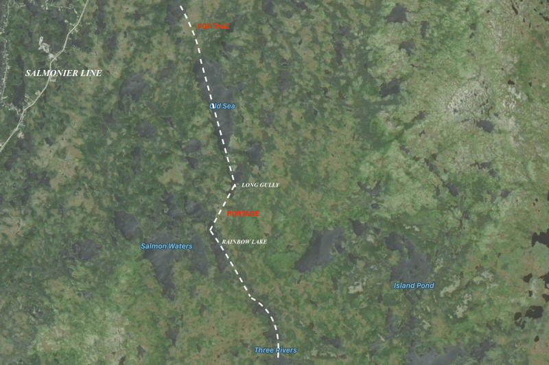
After portaging over from Old Sea you are now in Split Rock Pond. You will see cool cabin on the island just across from where you walk down the trail. From the shores of Split Rock you paddle to its North end. At this point you will notice to the left that there is a ramp going up to a canal. This dug out brook was widened to allow the aluminum boats of cabin owners to squeeze through and get into Split Rock. You will have to pull your vessel up onto the ramp, into the canal, and paddle it over into Peak Pond. This canal is a nice feature and a neat experience. As you go through it give yourself a pat on the back. All there is left to do now is to paddle up Peak Pond to the finish!


Make it Happen
Overall the paddling route is a great tour for the recreational tripper. You get to see a very scenic and protected area that is not utilized near enough. Moose, Caribou, Ducks, Geese, Loons and other wildlife is a common sight. In season the trouting and Salmon fishing can also be great. During all my days spent in there it is very surprising that I have never seen another paddler doing the entire route. It is a shame. I can’t imagine too many groups pass through there each year.
Every now and then we all need a break from the hyper-connected world we live in. It is healing for the mind and body. More beneficial than most can imagine until they experience it once. Why not round up a group, or if you are skilled enough try it on your own, and see what happens. I promise you will not be disappointed.
The time to plan is now. Big trips like this need to be organized well in advance in order to increase its chances of happening. People have to book time off and proper gear needs to be assembled.
If you have anymore well constructed questions feel free to drop me a line: justinbarbournl@gmail.com
Interested in a similar adventure through the Bay Du Nord Wilderness Area? Check out Twelve Days of Bush Living On Your Back . This post highlights gear I used to travel through that area during the Summer of 2016.
MORE PICTURES FROM PAST AWR TRIPS:


Always refreshing to view again, I did the canoe trip from Mount Carmel pond to Peak Pond on the Salmonier Line about 15+ years ago. A great experience.
Nice to hear Nelson. It is a nice refreshing trip and great experience no doubt. Fishing can be great too.
How many days did you take?
Hi Justin, I watch your videos on YouTube and they are great. I would like to know the name of the raft you have. I am planning on buying one in the spring and would you recommend that one. I have always wanted to canoe into Peak Pond and then to Old Sea. I may try it this summer.
That’s a great trip Greg as you know I highly recommend it. The raft is an ” Alpacka Raft” what an amazing piece of kit. Check out their website of the same name. Just punch it in google. Let me know if you have anymore questions! Thanks for watching the vids
I will certainly check out the website. I may have some more questions for you if my plans go ahead .
Thanks for getting back to me so quickly. Much appreciated.
No problem all the best! Stay in touch